Lockup - Compact - Texture Reverse_web

REVOLUTIONARY TERRAINS_ PLURALITY

REVOLUTIONARY TERRAINS_ PLURALITY

RECOGNISING SIGNIFICANT SPATIAL, TEMPORAL AND OCCUPATIONAL LAYERS

Dr Rachel Hurst, Dr Katica Pedisic, Dr Matthew Bird
UniSA Masters of Architecture Research Practices 2019

LOCATION
Adelaide, Murray Bridge, Tailem Bend, Coonalpyn, Keith, Bordertown, Nhill; Dimboola, Warracknabeal
Kaurna, Ngarrindjeri, Ngargad, Bindjali Bodaruwitj, Jupagalk, Wergaia, Jadawadjali, Jaadwa, Wotjobaluk

Revolutionary Terrains is the result of a collaborative research workshop by UniSA Masters of Architecture students. It uses experimental ways of reading and depicting Australian regional landscapes, architecture, and artifacts as a terrain of colonial ambition, imposition, and obsolescence.

Across nine Aboriginal lands and declining country towns, 16 archetypal ‘monuments to the everyday’ were selected as evidence of conscious and incidental colonization. These town halls, silos, clubs, and courthouses were reimagined as speculative drawings of uncanny objects, invading the lands of First Nations peoples.

Each alien image is oriented simultaneously to origin, destination, and the star Acrux – central to the Emu in the Sky, Koodjal Koodjal Djookan, and Southern Cross constellations, significant to both First Nations and Western cultures. Animated as a 16-minute video, the ghostly journey superimposes multiple perspectives of place, occupation, time, and signification. What might be the ‘afterlife’ of the things we build if we consider and care for them in larger cultural, temporal, and celestial contexts?

PROJECT LEADERS
Dr Rachel Hurst, Dr Matthew Bird


PROJECT PRODUCTION
Dr Katica Pedisic


PROJECT ASSISTANTS
Rupert Piccoli, Edward Ramsay


PROJECT PARTICIPANTS
Agastya Adhar, Courtney Bain, Hana
Broughton, Nathan Buder, Hisham
El-Jourdi, Yong Gan, Ryan Herbst,
Blake McDougall, Milad Nahravani,
Alyssa Nelson, Bec O’Brien, Billy
Roumeliotis, Giulia Talotta, Shannon Wark

PROJECT INSTITUTION
University of South Australia.

Explore Further

REVOLUTIONARY TERRAINS_TOOLS

REVOLUTIONARY TERRAINS_ TOOLS

LOOKING AT ORDINARY THINGS WITH EXTRA-ORDINARY TOOLS

Dr Rachel Hurst, Dr Katica Pedisic, Dr Matthew Bird
UniSA Masters of Architecture Research Practices 2019

LOCATION
Murray Bridge Silos, Coonalpyn Institute, Coonalpyn Silos, Keith Garage, Keith Memorial Institute, Keith Silos, Bordertown Institute, Bordertown Town Clock, Bordertown Silos, Bordertown Bowling Club, Nhill Post Office, Warracknabeal Town Hall
Kaurna, Ngarrindjeri, Ngargad, Bindjali Bodaruwitj, Jupagalk, Wergaia, Jadawadjali, Jaadwa, Wotjobaluk

Revolutionary Terrains is a collaborative research workshop by UniSA Masters of Architecture students. It uses experimental ways of depicting Australian regional landscapes, architecture, and artifacts as a terrain of colonial ambition, imposition, and obsolescence.

Gathering photographic data on a group road trip across southeastern Australia, students selected recurrent typologies, the built evidence of both conscious and incidental colonization. From nine towns and Aboriginal lands, these 16 archetypal ‘monuments to the everyday’, such as post offices, courthouses, and silos, were reimagined as uncanny objects, rolling through – invading – the landscape.

Using hybrid analogue drawing and iPhone apps, individuals made multi-perspectival images of each edifice, layered simultaneously from origin, destination, and cosmic viewpoints. These depictions collapse traditional and contemporary representational tools but also the temporal stasis of conventional drawing. The basis for a final stage animation, the works connect the lineage of embodied hand-drawing to the currency of 21st-century virtual communication.

PROJECT LEADERS
Dr Rachel Hurst, Dr Matthew Bird


PROJECT PRODUCTION
Dr Katica Pedisic


PROJECT ASSISTANTS
Rupert Piccoli, Edward Ramsay


PROJECT PARTICIPANTS
Agastya Adhar, Courtney Bain, Hana
Broughton, Nathan Buder, Hisham
El-Jourdi, Yong Gan, Ryan Herbst,
Blake McDougall, Milad Nahravani,
Alyssa Nelson, Bec O’Brien, Billy
Roumeliotis, Giulia Talotta, Shannon
Wark


PROJECT INSTITUTION
University of South Australia

Explore Further

REVOLUTIONARY TERRAINS_ COLLABORATION

REVOLUTIONARY TERRAINS_ COLLABORATION

MULTIPLE VOICES IN REAL TIME AND PLACE

Dr Rachel Hurst, Dr Katica Pedisic, Dr Matthew Bird
UniSA Masters of Architecture Research Practices 2019

LOCATION
Adelaide, Murray Bridge, Tailem Bend, Coonalpyn, Keith, Bordertown, Nhill; Dimboola, Warracknabeal
Kaurna, Ngarrindjeri, Ngargad, Bindjali Bodaruwitj, Jupagalk, Wergaia, Jadawadjali, Jaadwa, Wotjobaluk

Revolutionary Terrains is a collaborative research workshop by UniSA Masters of Architecture students. A team of 18 students and architectural educators explored ways of reading and depicting Australian regional landscapes, architecture and artefacts as a terrain of colonial ambition, imposition and obsolescence.

Initial exercises played with unconventional and physical modes of researching place and space. Next, a group road trip from Adelaide to Warracknabeal, across nine Aboriginal lands and declining country towns, charted 16 archetypal ‘monuments to the everyday’ (e.g. post offices, courthouses and silos) as uncanny objects. These formed the material for a co-operative photographic journal, speculative drawings, animation and public exhibition.

Allied with Studiobird’s After Warracknabeal [2019] and Parallaxis for the Adelaide 2020 Festival, the project’s ostensible focus is the redundant 1890 Warracknabeal Court House, and its regeneration as a community artspace: but more critical is its role as an immersive educational experience for students, one that benefits from fresh eyes and tactics on familiar places.

PROJECT LEADERS
Dr Rachel Hurst, Dr Matthew Bird


PROJECT PRODUCTION
Dr Katica Pedisic


PROJECT ASSISTANTS
Rupert Piccoli, Edward Ramsay


PROJECT PARTICIPANTS
Agastya Adhar, Courtney Bain, Hana
Broughton, Nathan Buder, Hisham
El-Jourdi, Yong Gan, Ryan Herbst,
Blake McDougall, Milad Nahravani,
Alyssa Nelson, Bec O’Brien, Billy
Roumeliotis, Giulia Talotta, Shannon Wark


PROJECT INSTITUTION
University of South Australia.

Explore Further

Minus

MINUS

THE ARCHITECTURE OF SUBTRACTION

Louise Wright, Urban Lab, Monash Art, Design & Architecture

LOCATION
Birrarung, Bulleen, Naarm
Bolin Bolin, Wurundjeri Woi-wurrung Country

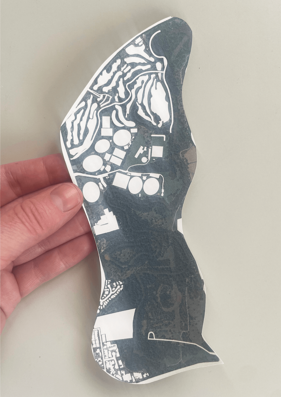
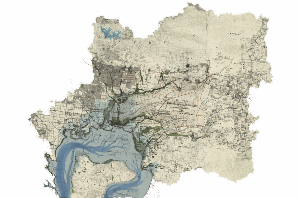
This tactic accounts for the post settlement occupation along the Birrarung, Naarm (Yarra River, Melbourne) by built form such as industrial buildings, carparks, sport fields and so on that disrupt and deny ecosystem functions through vegetation and habitat removal, sealing over of soil and ecosystem modification and fragmentation.

The tactic involves the ‘cutting out’ of built form from an aerial photograph making explicit the occupation and subsequent denial of life through the symbolic white space of the paper.

Widely applicable as a tactic, this example is from the riparian corridor of the Birrarung at the Bolin Bolin Billabong, a gathering site for the Wurundjeri Woi-wurrung and one of the few billabongs remaining in Melbourne

As a teaching tool the white space is considered: what was there, what could be reparative in the modified ecosystem, how does this white space interrupt systems at a micro and macro scale, what planning tools do we have and do we need to subtract built form rather than add, and can the programs removed exist elsewhere in novel ways that might in their turn regenerate an urban area?

TACTIC CONCEPTUALISATION
Louise Wright, Practice Professor

IMAGE PRODUCTION
Anne Barlow, Architecture Student

Explore Further

TRAVELLING UNDERGROUND

TRAVELLING UNDERGROUND

RE-TRACING MEMORY, STRUCTURES AND JOURNEYS WHICH HAVE BEEN COVERED UP

N’arweet Carolyn Brigs AM, Justin Buckley, David Chesworth, Taylor Coyne, Alexis Farr, Laura Harper, Xavier Ho, Ana Lara Heyns, Sonia Leber, Jon McCormack, Marilu Melo Zurita, Oscar Raby

LOCATION
VIC
Rippon Lea Estate, Elstenwick, City of Glen Eira, Melbourne
Boon Wurrung Country

Understanding and working with the deep structure of environments requires a suite of forensic processes. Map-making can garner such intelligence through the careful piecing together of diverse knowledges over time and space. This layered map of the Great Swamp catchment on Melbourne’s eastern edge reveals its dynamic past and underlying waterscape in the context of radical colonial change.

The map does not invent or project; it simply traces and records complexity, superimposing a version from one moment in time over another. This includes markings of explorers, records of subdivision and parish plans and the reconstruction of possible swamp zones, all shown in relation to topographic contours and geological features. The drawing, constructed using GIS technologies, includes archival material from a range of sources with different types of subjectivity overlaid and geo-positioned in relation to ‘official’ contemporary datasets. Further detective work includes recordings, which make ‘natural’ sounds audible by placing hand made microphones in mud on the ground, and enable deep time connection to the ‘material’ of place through the rhythmic patterns of Boonwurrung language.

INDIGENOUS ELDER
N’Arwee’t Professor Carolyn Briggs
AM

CLIENT
National Trust of Australia – Victoria,
Justin Buckley


FUNDING
Australian Heritage Grant
AHGII000002, Rippon Lea
Endowment Fund, The Drain Man


PROJECT LEAD
Laura Harper


RESEARCH TEAM
N’Arwee’t Professor Carolyn Briggs
AM, Justin Buckley, Taylor Coyne,
Alexis Farr, Laura Harper, Ana Lara
Heyns, Maria de Lourdes Melo Zurita,
Jon McCormack


IMMERSIVE EXPERIENCE AND AR
Oscar Raby


SOUND RECORDING AND COMPOSITION
David Chesworth, Sonia Leber, Taylor
Coyne,


WEB DESIGN
Xavier Ho


IMAGE CREDIT
Laura Harper, Ana Lara Heyns

Explore Further

MAKING SOMETHING OF / FROM WHAT REMAINS

MAKING SOMETHING OF / FROM WHAT REMAINS

SUBTRACTING DEFINITIVELY, UPGRADING NECESSARILY. REMEDIATING VISIBLY, ALTERING SLIGHTLY, ADDING PROVISIONALLY, ARTICULATING MATTER-OF-FACTLY.

Gilby + Brewin Architecture

LOCATION
TAS
Freestone Point, Triabunna
Traditional Lands of the paredarerme, trayapana, lutruwita

For millennia, the Spring Bay Mill site has been a significant place of cultural and social gathering for the Palawa / Pakana people. However, in recent decades the site operated as what was once the world’s largest wood- chipping plant where up to 100,000 native trees were reduced to chips each year.

Since the abandonment of the plant in 2010, this extensively damaged site is being repaired and transformed into a culture and environment focussed events venue, reorienting the site back towards the deep past as a place of human gathering.

The project has been undertaken with the tactic of making something of (figuratively) and from (literally) what remains of the former use(s) of the site.

This is actioned by:

  • subtracting definitively,
  • upgrading necessarily,
  • remediating visibly,
  • altering slightly,
  • adding provisionally,
  • articulating matter-of-factly,

Aiming to do the least needed to convert the use of the site, while making apparent and available for experience, the contemporary processes, parts and programmes that contribute to the site’s repair and regeneration, as these overlap with the recent industrial history, postcolonial context, and the ancient landscape setting.

gilbybrewin.com.au

OWNERS
Greame Wood & Anna Cerneaz

SITE MASTER PLAN AND ARCHITECTURE
Gilby + Brewin Architecture (Ross Brewin, Anna Gilby, Shing Hei Ho, Nina Tory-Henderson)

LANDSCAPE DESIGN
Verdant Way (Marcus Ragus)

DESIGN COLLABORATORS
Futago (Wayfinding signage), Studio Ferri (Banksia Room interior design), Laura McCusker (Banksia Room furniture design), Michelle Boyde, Chloe Proud, Wellington Steelworks (Tin Shed Courtyard outdoor kitchen), Vanishing Point Design (Preliminary Stage consultant coordination & documentation),

CONSTRUCTION
Dillon Builders (Site services & infrastructure and all buildings),
AJR Construct (Ridge Quarters pre- fabricated units),
Eagle Ridge Consulting (Preliminary Stage site wide project management & construction and Beach Shacks design & construct).

CONSULTANTS
Saltmarsh & Escobar Consulting Engineers (Structural and civil engineering), Andrew Sutherland Consulting Engineers (Services engineering), EHome AV (Audio Visual), Holdfast Building Surveyors (Building surveying), Cultural Heritage Management Australia (Aboriginal cultural heritage assessment), North Barker Ecosystem Services (Sitewide fire hazard management),
COVA and Kojin Engineering (Tin Shed fire engineering),
Wormald (Hydraulic engineering)

PHOTOGRAPHY
Adam Gibson
Richard Jupe
Vica Bayley
Gilby Brewin

Explore Further

MELBOURNE METABOLISING

MELBOURNE METABOLISING

MELBOURNE METABOLISING

MELBOURNE METABOLISING

LOCATION
VIC
Melbourne
Naarm, Boon Wurrung and Woi Wurrung Country

Melbourne Metabolising is a temporal morphological study of Melbourne/Naarm’s Hoddle Grid that can be updated in the coming years and used in a variety of ways. Naarm sits on the land of the 5 clans of the Kulin Nation. The research borrows from the extension of dynamic legacies of Metabolist thinking relating to processes that affect urban growth and decline.

Research tactics:

  • Collating fragments of Melbourne’s Hoddle Grid through research into historical maps and photographs using public archives.
  • Exploring narratives through parallel timelines of economic forces, planning, and extractive resource booms that affect the morphology and typology.
  • Future speculations using dynamic algorithmic simulation.

Format
The contribution is an ongoing open-source project 50% finished, conducted by students at Monash University. The intended format is GIS shapefiles with data fields, embedded in a web page where users can scroll to a timeline to any point and view the state. Data fields include year constructed, demolition, height, program, and material. The research provides various lessons and trajectories, with the aim of providing critical commentary on probable future directions.

RESEARCH LEADER
Peter Charles


COMPILATION
Zeming Wang, Iris Leung, Caleb
Utembe, Carol Chia Jung Li, Erol Gok


CONTRIBUTORS
Carol Chia Jung Li, Iris Leung, Yueran
Gao, Faitma Yousuf, Caleb Utembe,
Zeming Kyle Wang, David Zhou, Erol
Gok, Tong Zhao, Jiaming Ge, Zahra
Aamiry, Maryam Kahan, Cara Cabriel,
Myounggi Jeong, Zhenyao Xu.

Explore Further

ALUMINIUM EXTRACTION URBANISM

ALUMINIUM EXTRACTION URBANISM

SYSTEMS ANALYSIS AND MAPPING OPPORTUNITIES

Peter Charles, Monash University

LOCATION
VIC
Portland
Gunditjmara Country

The study uses mapping and diagramming tactics to explore resource extraction systems in relation to towns with processing smelters separated from resource extraction sites. These are used to identify sites for stimulators that focus on new carbon economies and environmental tourism.

Tactics include using Food-web and Sankey diagrams to explore aluminium processing systems, and Patrick Geddes Sieve method to explore the intersection of map layers combining concepts from Landscape Urbanism and Industrial Ecology. Environmental maps are created using Arduino microprocessors, environmental sensors, GPS, and GIS.

The tactics were applied to Portland, a pivotal port town 550km west of Melbourne which was the first European settlement in Victoria and holds world heritage Gunditjmara agricultural sites.

Portland has a relatively new aluminium smelter with a subsidised energy contract to 2036 from the Loy Yang Power station, located 500km away in the La Trobe Valley. The Bauxite that is smelted is also mined far away. The potline of the smelter can be used as a battery to stabilise energy flow. The smelter uses 10% of Victorian energy, playing a large role in decisions related to carbon and the economy.

RESEARCH LEADER
Peter Charles


CONTRIBUTORS
Chia Jung Carol Li, Aidan Hoyne,
Anna Chan, James Owens, Jess
Hordern, Marlow Brown, Yueran
Vera Gao, Swasti Jain, Kittaporn
Bamroong, Lingyuan Sydney Zhang,
Spike Thomson, Emily Foenander,
Natsumi Maeda, Aleez Vasaya, Erol
Gok

Explore Further

OPENNESS TO WATER’S UNRULY HABITS

OPENNESS TO WATER'S UNRULY HABITS

INSPIRING PROCESSES OF MEMORY, REPAIR AND STEWARDSHIP

baanytaageek: Great Swamp Regenerative Collective

LOCATION
VIC
Tae Rak (Lake Condah)
Gunditjmara Country

Research into the after-effects of modernity leads us to visit examples of ‘post-industrial hybrids’ – cumulative landscapes that absorb past actions as they are modified and adapted to dynamic conditions. The deep-time processes of the Gunditjmara people of Tae Rak (Lake Condah) in south-west Victoria show how careful interventions enable stewardship, repair, and rehabilitation of water systems.

For thousands of years, these Traditional Owners rearranged volcanic rocks that covered the low-lying plains below Budj Bim (Mt Eccles) to create a series of linked ponds that formed an eel-trap system. This is an example of a modified and augmented natural water landscape, generating cultural trade and allowing sustained human occupation. Construction of a small concrete weir across the remnant drainage channel allows Tae Rak to fill part way towards its natural level and makes a crossing, as seen in this photo; negotiations with adjacent landowners may progress to raise this level to its maximum floodable extent. The return of semi-permanent water brings back insects and birdlife, and with that comes a range of wetland plants re-establishing themselves in the previously drained farmland.

AUTHORS:
Nigel Bertram
Catherine Murphy


CONTRIBUTORS
N’arwee’t Carolyn Briggs
Daniel Kotsimbos
Rutger Pasman
Ben Waters


IMAGE
Monash architecture students
traversing the new concrete weir
(design by GHD) damming the outlet
drain at Lake Condah. Photograph by
Piers Morgan, 2016.

Explore Further

DETECTIVE WORK

DETECTIVE WORK

LAYERS OF EVIDENCE TO GARNER SWAMPLAND INTELLIGENCE

baanytaageek: Great Swamp Regenerative Collective

LOCATION
VIC
Cardinia and Koo Wee Rup
Boon Wurrung Country

Understanding and working with the deep structure of environments requires a suite of forensic processes. Map-making can garner such intelligence through the careful piecing together of diverse knowledges over time and space. This layered map of the Great Swamp catchment on Melbourne’s eastern edge reveals its dynamic past and underlying waterscape in the context of radical colonial change.

The map does not invent or project; it simply traces and records complexity, superimposing a version from one moment in time over another. This includes markings of explorers, records of subdivision and parish plans and the reconstruction of possible swamp zones, all shown in relation to topographic contours and geological features. The drawing, constructed using GIS technologies, includes archival material from a range of sources with different types of subjectivity overlaid and geo-positioned in relation to ‘official’ contemporary datasets. Further detective work includes recordings, which make ‘natural’ sounds audible by placing hand made microphones in mud on the ground, and enable deep time connection to the ‘material’ of place through the rhythmic patterns of Boonwurrung language.

AUTHORS:
Nigel Bertram
Catherine Murphy

CONTRIBUTORS
N’arwee’t Carolyn Briggs
Daniel Kotsimbos
Rutger Pasman
Ben Waters

IMAGE AUTHORSHIP
Great Swamp Catchment drawing
by Monash Urban Lab with Rutger
Pasman, 2023.

Explore Further