YURI INGARNINTHII: DEEP LISTENING

YURI INGARNINTHII: DEEP LISTENING

TRANSCENDING SUPERFICIAL OBSERVATION USING THOUGHTFUL PROCESSING SKILLS TO UNDERSTAND WHAT YOU’RE LOOKING AT

LOCATION
SA
Yarta Puulti (‘Sleeping Place’), Estuarine Mangrove River System, Port Adelaide,
South Australia, 34.51S 135.30E
Kaurna Yarta

Our approach to consultation has been more relational than formal. We requested permission to join the Kaurna community to listen and learn about Kaurna Yarta. In exchange, we brought skills and experience in architecture, landscape architecture, and place-making to assist in the coming together of the physical and the cultural topographies shaping the project.

The concept plan for Yitpi Yartapuultiku (the ‘Soul of Port Adelaide’) has been delivered through an extensive co-design process that has involved loosely structured design workshops and lots of ‘yarning’. By adopting a process of deep listening, the project team developed an interactive engagement process that used making and doing to explore the potential place-making opportunities. Using a unique process of physical modeling with kinetic sand, the custodian groups were able to shape the site with their own hands, explore landforms, build mounds, and shape the site’s edges. They tested spatial arrangements, coastal edge profiles, and discussed how cultural practices and narratives should be expressed, overlaid, and embedded into the concept plan.

participate.cityofpae.sa.gov.au/yitpiyartapuultiku

CLIENT
City of Port Adelaide Enfield


CULTURAL DIRECTION
Kaurna Traditional Owners and Custodians


ARCHITECT / PROJECT LEAD
Ashley Halliday Architects


LANDSCAPE ARCHITECT
Wax Design


INTERPRETIVE DESIGN /
WAYFINDING
Exhibition Studios


FILM MAKING
Living Stories


PROJECT MANAGER
Moto Projects


CULTURAL DESIGN FACILITATOR
Brave & Curious


DESIGN COLLABORATORS
PT Design, Lucid, RLB, Cirqa,
Wavelength, Golder, Succession,
Ecology, Resonate, Eatscape, D Squared, Buildsurv

Explore Further

INTEGRATING ARCHITECTURE & LANDSCAPE ARCHITECTURE LEADERSHIP

INTEGRATING ARCHITECTURE & LANDSCAPE ARCHITECTURE LEADERSHIP

INTEGRATING ARCHITECTURE & LANDSCAPE ARCHITECTURE LEADERSHIP

Ashley Halliday Architects, Wax Design, the City of Port Adelaide Enfi eld, Kaurna Traditional Owners
and Yitpi Yartapuultiku Custodian Group

LOCATION
SA
Yarta Puulti (‘Sleeping Place’), Estuarine Mangrove River System, Port Adelaide,
South Australia, 34.51S 135.30E
Kaurna Yarta

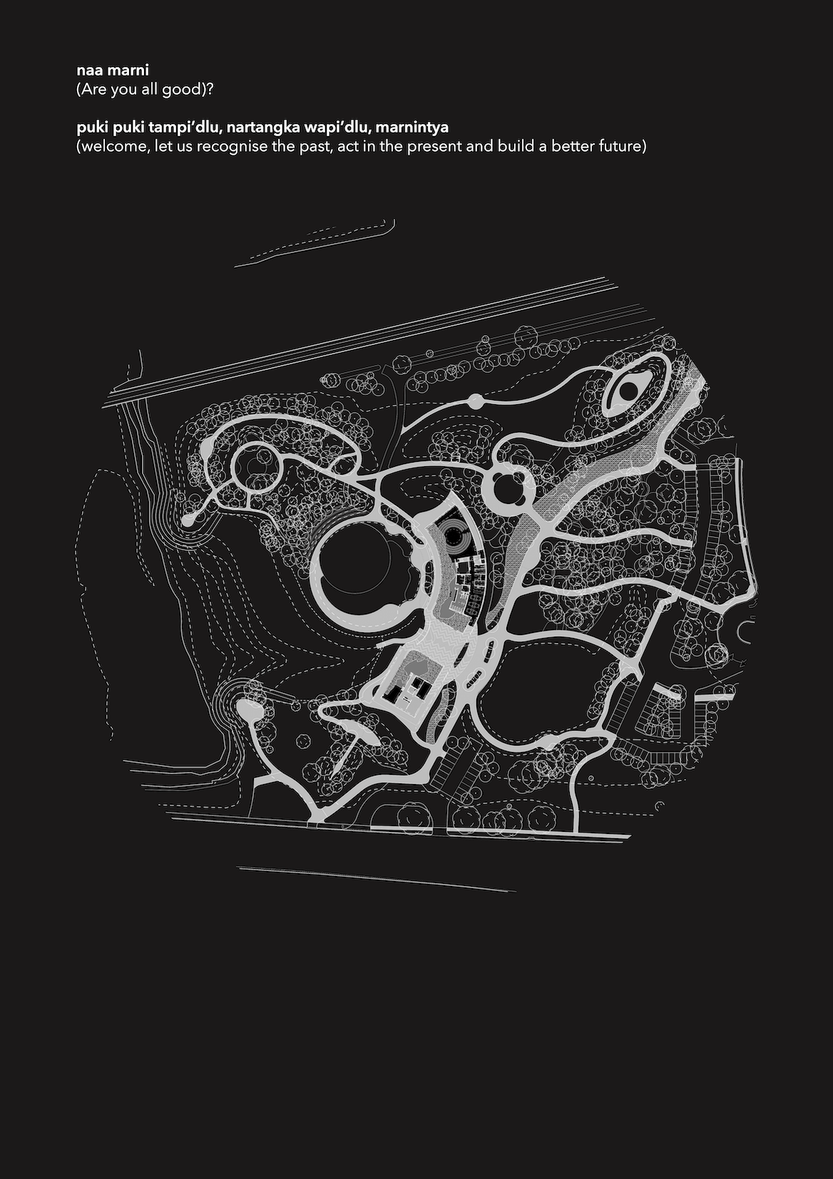
Yitpi Yartapuultiku translates as ‘Soul of Port Adelaide’ in Kaurna and is located on Yarta Puulti (‘Sleeping Place’), Estuarine Mangrove River System, Port Adelaide. Yitpi Yartapuultiku is a place for Aboriginal and non-Aboriginal people to be immersed in and learn from Aboriginal culture. Landscape and architecture are sensitively curated under strong cultural direction to create a unique, cohesive, culturally safe place that respects, nurtures, and celebrates Country. Yitpi Yartapuultiku demonstrates what it means to be ‘On Country’ – a process vital to people’s cultural, spiritual, and physical wellbeing.

Architecture, Landscape, Munaintya (Kaurna Dreaming), and ecology are holistically interwoven, designed to spark curiosity, connect people with Nindi (all senses), to the spirit of the place, with each other, and with Country.

The site plan is a powerful planar representation of the deep listening, learning, and knowledge shared by the traditional owners and custodians and is the direct product of a highly participatory integrated design process. The design is infused with deep symbolic purpose and spiritual meaning.

participate.cityofpae.sa.gov.au/yitpiyartapuultiku

CLIENT
City of Port Adelaide Enfield
CULTURAL DIRECTION
Kaurna Traditional Owners and
Custodians


ARCHITECT/PROJECT LEAD
Ashley Halliday Architects


LANDSCAPE ARCHITECT
Wax Design


INTERPRETIVE DESIGN/WAYFINDING
Exhibition Studios
FILM MAKING
Living Stories


PROJECT MANAGER
Moto Projects


CULTURAL DESIGN FACILITATOR
Brave & Curious


DESIGN COLLABORATORS
PT Design, Lucid, RLB, Cirqa,
Wavelength, Golder, Succession
Ecology, Resonate, Eatscape, D
Squared, Buildsurv
Explore Further

MELBOURNE METABOLISING

MELBOURNE METABOLISING

MELBOURNE METABOLISING

MELBOURNE METABOLISING

LOCATION
VIC
Melbourne
Naarm, Boon Wurrung and Woi Wurrung Country

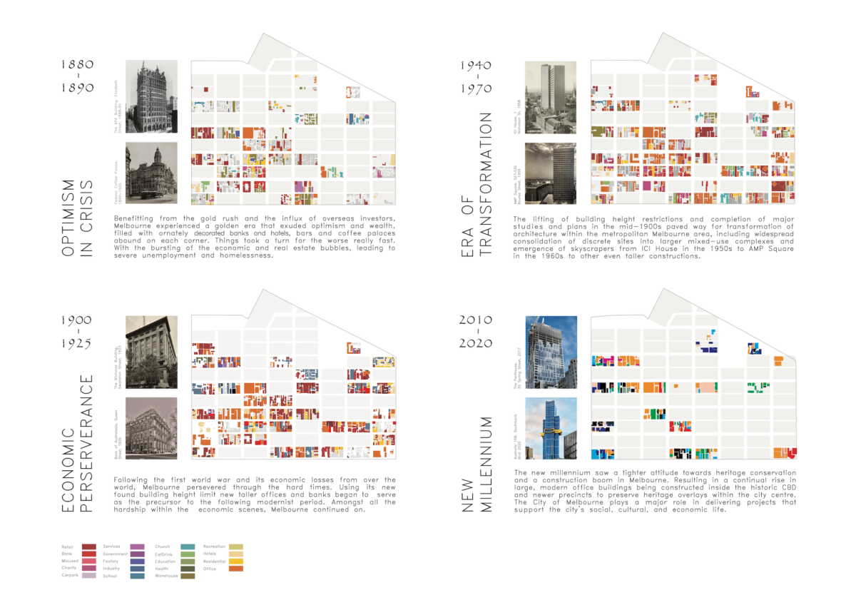
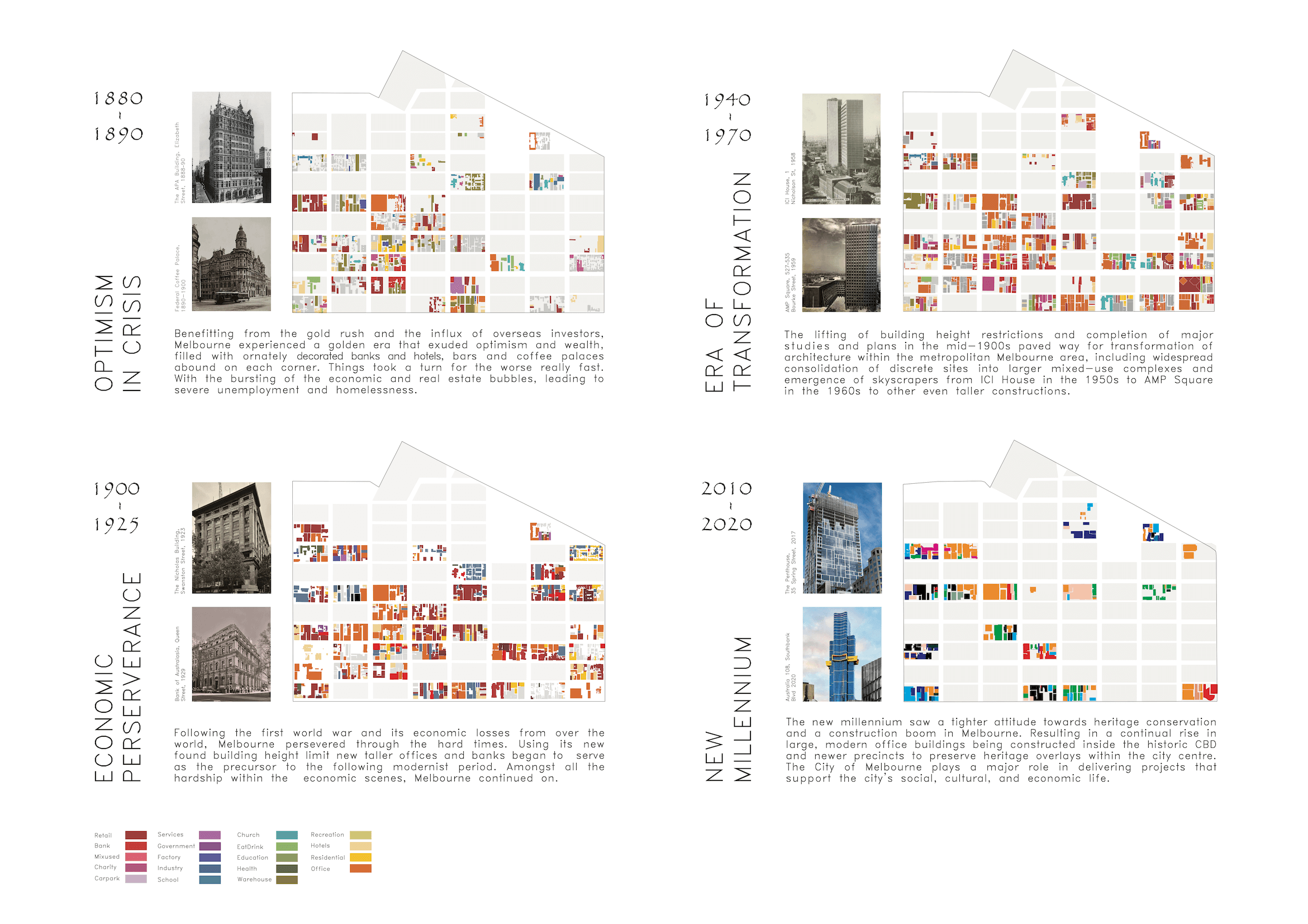
Melbourne Metabolising is a temporal morphological study of Melbourne/Naarm’s Hoddle Grid that can be updated in the coming years and used in a variety of ways. Naarm sits on the land of the 5 clans of the Kulin Nation. The research borrows from the extension of dynamic legacies of Metabolist thinking relating to processes that affect urban growth and decline.

Research tactics:

  • Collating fragments of Melbourne’s Hoddle Grid through research into historical maps and photographs using public archives.
  • Exploring narratives through parallel timelines of economic forces, planning, and extractive resource booms that affect the morphology and typology.
  • Future speculations using dynamic algorithmic simulation.

Format
The contribution is an ongoing open-source project 50% finished, conducted by students at Monash University. The intended format is GIS shapefiles with data fields, embedded in a web page where users can scroll to a timeline to any point and view the state. Data fields include year constructed, demolition, height, program, and material. The research provides various lessons and trajectories, with the aim of providing critical commentary on probable future directions.

RESEARCH LEADER
Peter Charles


COMPILATION
Zeming Wang, Iris Leung, Caleb
Utembe, Carol Chia Jung Li, Erol Gok


CONTRIBUTORS
Carol Chia Jung Li, Iris Leung, Yueran
Gao, Faitma Yousuf, Caleb Utembe,
Zeming Kyle Wang, David Zhou, Erol
Gok, Tong Zhao, Jiaming Ge, Zahra
Aamiry, Maryam Kahan, Cara Cabriel,
Myounggi Jeong, Zhenyao Xu.

Explore Further

LEARNING COUNTRY

LEARNING COUNTRY

MINUTE PORTALS

Jane Caught, Heliotope

LOCATION
various locations
First Nations Country as noted on image

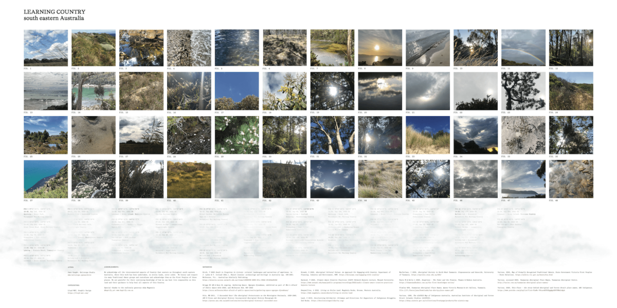
Australia and its architecture tend to transplant ideas of place, form, and seasonality from afar, privileging a Western worldview. This tactic starts to learn place by collecting minute-long video recordings, capturing movement and sound; light interacting with the landscape; glittering spiders’ webs in the sun; breezes over native grasses. They become an archive, reflecting seasonal temporality and recording what actually occurs here across the year, to understand local micro-ecologies, to preserve a memory of Here, before it sustains radical change as our planet warms.

The videos are provocations – where exactly are you standing, gazing, all senses alive, for this minute? Whose traditional lands do you stand on? By what names were it known? What knowledge is embedded in this landscape? What were its cyclical, interconnected constructs? Each piece locates spatial coordinates; time and date stamps – Cartesian markers acting as portals to alternate perspectives. They demand questions that start to reveal both pre-settler experiences as well as the effects of colonisation on First Nations peoples. The act of researching an original place name reveals truth-telling and engenders relationships.

heliotope.com/Learning-Country-Archive

Explore Further

DETECTIVE WORK

DETECTIVE WORK

LAYERS OF EVIDENCE TO GARNER SWAMPLAND INTELLIGENCE

baanytaageek: Great Swamp Regenerative Collective

LOCATION
VIC
Cardinia and Koo Wee Rup
Boon Wurrung Country

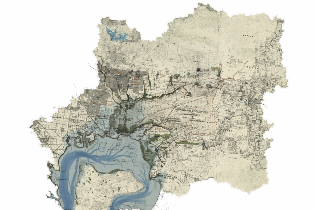
Understanding and working with the deep structure of environments requires a suite of forensic processes. Map-making can garner such intelligence through the careful piecing together of diverse knowledges over time and space. This layered map of the Great Swamp catchment on Melbourne’s eastern edge reveals its dynamic past and underlying waterscape in the context of radical colonial change.

The map does not invent or project; it simply traces and records complexity, superimposing a version from one moment in time over another. This includes markings of explorers, records of subdivision and parish plans and the reconstruction of possible swamp zones, all shown in relation to topographic contours and geological features. The drawing, constructed using GIS technologies, includes archival material from a range of sources with different types of subjectivity overlaid and geo-positioned in relation to ‘official’ contemporary datasets. Further detective work includes recordings, which make ‘natural’ sounds audible by placing hand made microphones in mud on the ground, and enable deep time connection to the ‘material’ of place through the rhythmic patterns of Boonwurrung language.

AUTHORS:
Nigel Bertram
Catherine Murphy

CONTRIBUTORS
N’arwee’t Carolyn Briggs
Daniel Kotsimbos
Rutger Pasman
Ben Waters

IMAGE AUTHORSHIP
Great Swamp Catchment drawing
by Monash Urban Lab with Rutger
Pasman, 2023.

Explore Further